
Transforming Site Management Through Precision Aerial Intelligence
Southern Drone Data Solutions empowers construction, real estate development, and aggregate production companies to make data-driven decisions with confidence. Our drone-powered volumetric analysis, progress tracking, and terrain mapping eliminate guesswork and expose critical site insights that traditional methods miss.
We can help you discover hidden costs, verify contractor work, and optimize material management with survey-grade accuracy.
Advanced Aerial Data Solutions for Critical Business Decisions
We combine cutting-edge drone technology with industry expertise to deliver actionable intelligence that solves real business challenges. Each of our specialized services is designed to provide the precise data you need for confident decision-making.


How Drone Progress Tracking Saved a Developer $100,000 in a Contract Dispute
A subdivision developer in the region who regularly implements systematic monitoring of all development sites using drone technology.

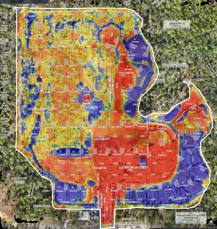
How Aerial Surveys Revealed a $400,000 Hidden Expense in South Louisiana Real Estate Development
A homebuilder based in Louisiana was considering purchasing multiple lots in South Louisiana that were being marketed as "Form Board Ready" with "minimal improvement" needed before construction could begin.

Specialized Solutions for High-Value Applications
Our services are specifically designed for industries where accurate site data directly impacts financial outcomes:
The return on investment is clear: our clients typically recover our service costs many times over through error prevention, dispute avoidance, and operational improvements.
Why Industry Leaders Choose Southern Drone Data Solutions
Our practical industry experience and technical expertise deliver measurable advantages:
The return on investment is clear: our clients typically recover our service costs many times over through error prevention, dispute avoidance, and operational improvements.
Beyond Standard Drone Services
Our approach combines advanced technology with industry-specific expertise:
We don't just deliver raw data—we provide insights that directly address your business challenges.
.png)